GPSTrack
Overview
Its a little piece of software that connects to a GPS device and spits out a KML file of the data as it comes in along with a KML file that you can pull into google earth and it will refresh once a second. Google earth can crash and spit and whine, but the data is safe unless, of course, the computer locks up.
The software isn't perfect, but its robust. Its written in QT and is therefore somewhat large. But it is simple and the interface is great. I'd be willing to add features if anyone is interested in using it, but until then it stands as it is.
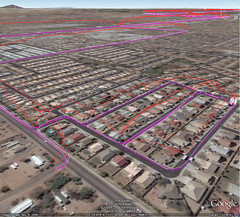
What is plotted
- A ground track is plotted (pink)
- A 3D track is plotted (white with grey walls to the ground level)
- Velocity vs Altitude is plotted (as a red floating line which varies its height from ground level)
Why Did You Write This?
The code was originally part of the Spicerack. It was designed to remotely track a high altitude balloon for quick and reliable retrieval. It was a simple matter to excise the code from the larger program and re-write the wrapper. Its very useful for driving around in strange cities and not getting lost :)
Download
GPSTrack is free to use and there are no restrictions. It would be nice to hear about your experiences in order to better develop the software.
Download GPSTrack V1.0 R2 - Serial Error bug fixed (11-10-2009)
2009 Jasper Nance KE7PHI